 Kiosk
Kiosk

Discussion Forums - 2009 Resolutions
Topic: Also just testing
| Unlock Forum posting with Annual Membership. |
|
|||
|
Saving space for future planning |
|||


|
|||
|
Saving space for future planning |
|||
|
|||
|
Saving space for future planning |
|||
|
|||
|
Saving space for future planning |
|||
|
|||
|
Saving space for future planning |
|||
|
|||
|
Saving space for future planning |
|||
|
|||
|
Saving space for future planning |
|||
|
|||
|
Saving space for future planning |
|||
|
|||
|
Saving space for future planning |
|||
|
|||
|
Last Edited on: 3/1/25 1:09 PM ET - Total times edited: 4 |
|||
|
|||
|
Today we will look at some of the wildflowers that grow in Gates of the Arctic ---
Last Edited on: 2/28/25 10:26 PM ET - Total times edited: 1 |
|||
 Gorman’s Dwarf-Primrose
 Alpine Willow
 Moss Campion
 White Arctic Mountain Heather
 Yellow poppy
 Eightpetal Mountain-avens
 Nodding Arnica
 Dwarf Fireweed
 Pale Gentian
 Heartleaf Saxifrage
 Smooth Cliff Fern
 Arctic Lousewort
 Northern Larkspur
 Arctic Alpine Forget-Me-Not
 Arctic Alpine Fleabane
 Dwarf Alpine Hawksbeard
|
|||
|
Saving space for future planning |
|||
|
|||
|
Saving space for future planning |
|||
|
|||
|
Saving space for future planning |
|||
|
|||
|
Saving space for future planning |
|||
|
|||
|
SOME OF THESE ARE LOW ON STOCK....DOUBLE CHECK BEFORE OFFERING
Last Edited on: 3/28/25 6:06 PM ET - Total times edited: 5 |
|||
 Christmas Ornament. Tree of Life. Approx. 2.5" x 2.5"
 Christmas Ornament. Bird Family. Approx 3" x 3"
 Compass Star Acrylic Window Hanging. Indoor. 6" x 6"
 Owl Acrylic Window Hanging. Indoor. Approx 6" x 6"
 Sunflower Acrylic Window Hanging. Indoor. Approx 6" x 6"
 Stain Glass Dragonfly Window Hanging, Indoor / Outdoor. Approx 7.8" x 7.8"
 Solar Garden Bird Light.
  Make Your Own Garden Stepping Stone. Activity to do with kids or grandkids.
 Sunflower garden flag (flag only, not the stand)
 Butterfly garden flag (flag only, not the stand)
 Birds in tree garden flag (flag only, not the stand)
|
|||
|
Last Edited on: 3/18/25 12:04 AM ET - Total times edited: 14 |
|||
 Honey & Almond. Warm almond is enveloped in honeyed vanilla, bringing the warmth and comfort of homesteads long forgotten.
  Black Forest. This soft and seductive fragrance is evocative of the mystery of its name sake. In the comfort of the woods a warm amber is sweetened by delicate Tobacco flowers in this sultry, earthy blend.
 Citrus Bliss. An energizing fusion of zesty lemon and tangy lime, this vibrant experience will leave you feeling fresh and invigorated.
 Colorful Colorado. White lilies and sweet pea petals steeped in red clover tea are perfectly paired with raspberries, pineapples, and nectarines.
 Garden of the Gods. Spring clover and tender greens sharply contrast the sandstone exposed by the uplift of the Rocky Mountains, inviting one to remember not all spa experiences are indoors.
 Lavender Fields. This iconic floral fragrance gracefully unlocks stress and tension as it evokes the senses of gently running your fingertips over the small lavender blooms.
 Mooseberry. A captivating blend of deep red berries and rich vanilla, perfectly accented with a whisper of spice, leaves you feeling right at home in the Rocky Mountains.
|
|||
|
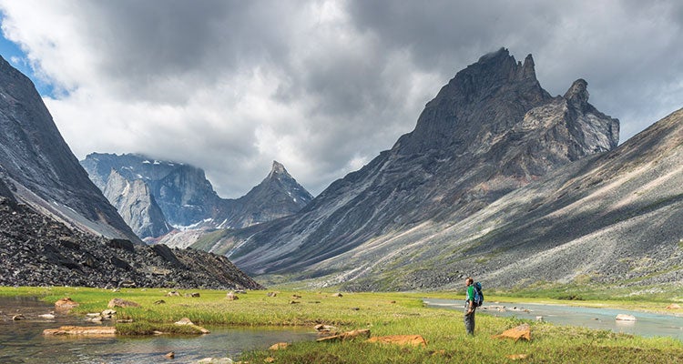
Today we will look at some of the "Things To Do" in Gates of the Arctic --- The primary "Thing To Do" in Gates of the Arctic is be alone and find yourself, away from the norms of everyday life. You also must trust yourself and your abilities. No matter how long one visits or how they spend their time, NPS stresses the fact that you're on your own. This is the number one message visitors must know and apply to their visit to Gates of the Arctic. There is no cell phone service and there are no amenities other infrastructure. Visitors may not see another person until they return to civilization or their pilot comes back. Visitors must be entirely self-reliant and able to execute self-extraction and communication, should an emergency situation arise.
Backpacking and Hiking
Traveling through the park on foot affords opportunities of exploration and discovery. Mountain ridges and passes reveal splendid vistas and can take visitors to the most remote and least traveled areas of the Park and Preserve. Experienced hikers in the Gates of the Arctic National Park & Preserve consider six miles a good day's travel. Since there are no established trails, visitors find it easiest to walk above the tree line or in the streambeds, if the water level is low. Topographic maps and a reliable compass are essential.
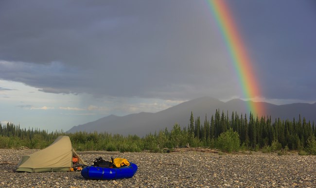
Camping
There are no designated campsites in Gates of the Arctic National Park and Preserve. Camping in the arctic requires planning, preparation and care in order to protect the visitor and the fragile arctic ecosystem. Arctic tundra is surprisingly fragile and slow to recover. It is best to camp on durable surfaces. Before you leave, make every effort to return your campsite to a natural appearance. Leave no trace.
Fishing
Gates of the Arctic National Park and Preserve provides unique fishing opportunities unlike anywhere else in Alaska. While there are areas and seasonal times of abundance, because of the general low productivity of arctic waters, the park encourages catch-and-release fishing or ask visitors to keep only what can be immediately consumed.
Last Edited on: 3/4/25 1:42 PM ET - Total times edited: 10 |
|||

|
|||
|
Last Edited on: 2/26/25 2:51 PM ET - Total times edited: 8 |
|||
|
|||
|
Saving space for future planning |
|||
|
|||
|
Saving space for future planning |
|||
